Golden Ultra 60K Race Report

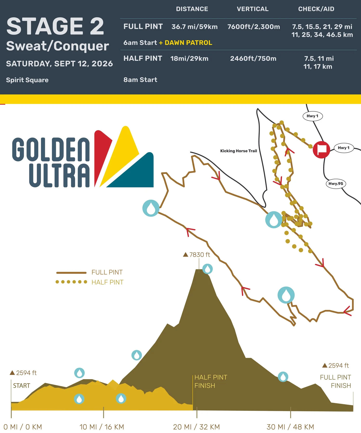
Race: The Golden Ultra 60K – Stage 2 – Sweat & Conquer

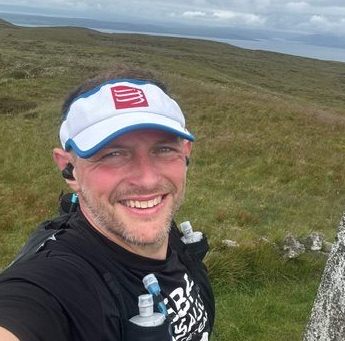
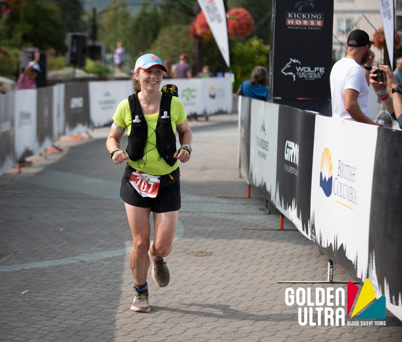
Runner: TRR Coach Jennifer Kozak

Race Date: 09/13/2025

Location: Golden, British Columbia, Canada

Result: 9th/46 in age group for the single day event, 19th/90 of all women running the 60K (both single and three-day participants)

Strava link: https://www.strava.com/activities/15801575706/overview

TRR Coach Jennifer Kozak running the Golden Ultra 60K race. PC: Jonathan McLeod
3 Bests – What aspects of the race did you like the most?

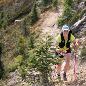
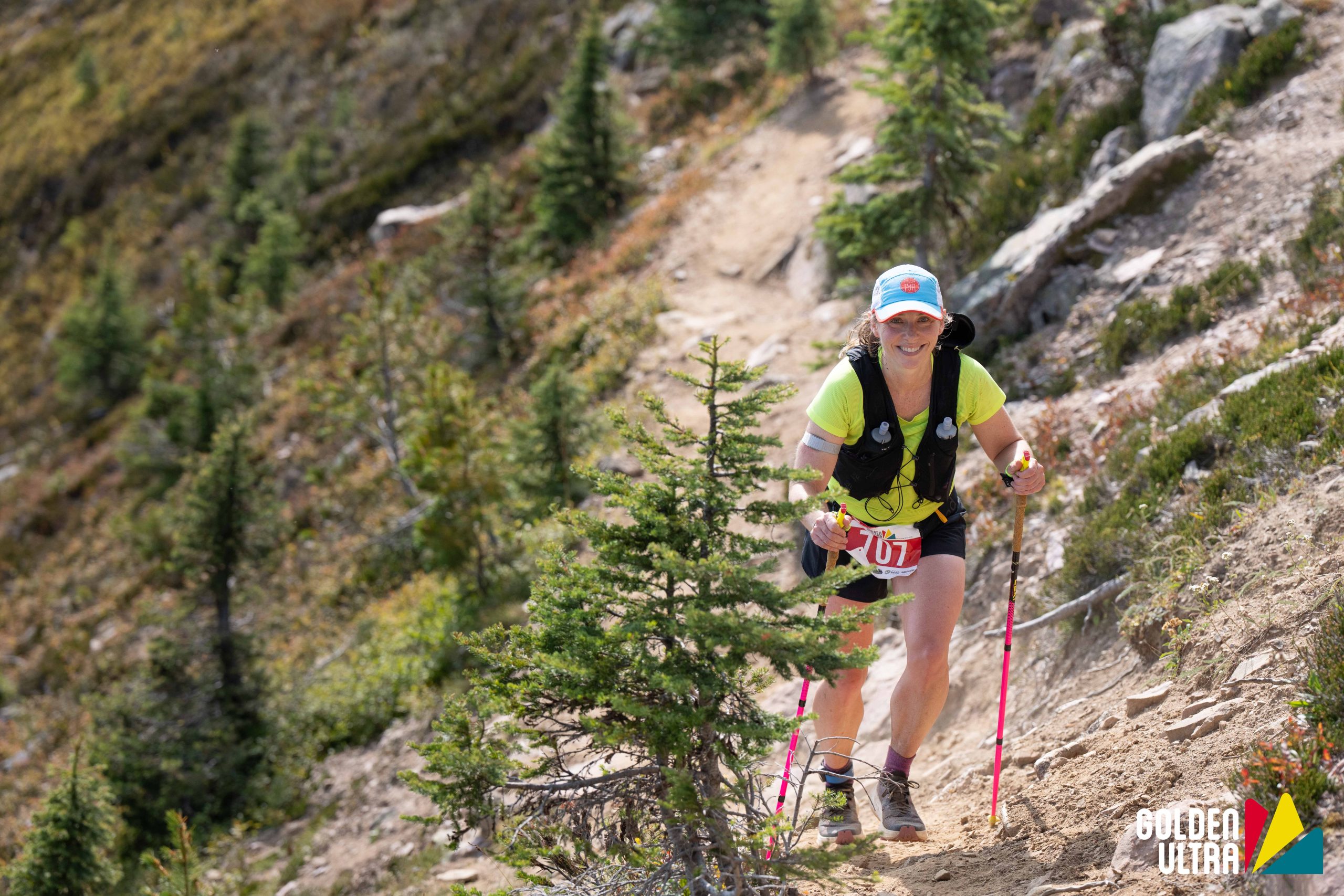
The Golden Ultra is a three-day stage race or a one-day ultra running race in Golden, BC, Canada. I chose the one-day, 60K ultra option.

1. Volunteers/Aid stations: This was by far the highlight of the race for me! The aid station volunteers went so above and beyond, it felt like I had crew! I would arrive, and immediately one person was helping me find my drop bag, while two other people were filling my bottles, and a fourth was holding my poles. They put ice in my hat, dumped water down my back, offered me tater tots, bacon, and quesadillas, all while telling me how good I looked, ha! As we approached the summit for the day, we were greeted with a team of dancing men dressed as fairies encouraging us up to the top. All of these amazing people meant I had a smile on my face for most of the day.

2. Flagging: The course was very well marked for the day. The few instances where I was worried that I had taken a wrong turn, I simply had to wait one minute, and the next flag would appear. Any turn was either manned or flagged so well that you knew exactly where to go. Despite some hesitancy that I missed something when I ultimately would zone out for a while, not a single turn was missed.

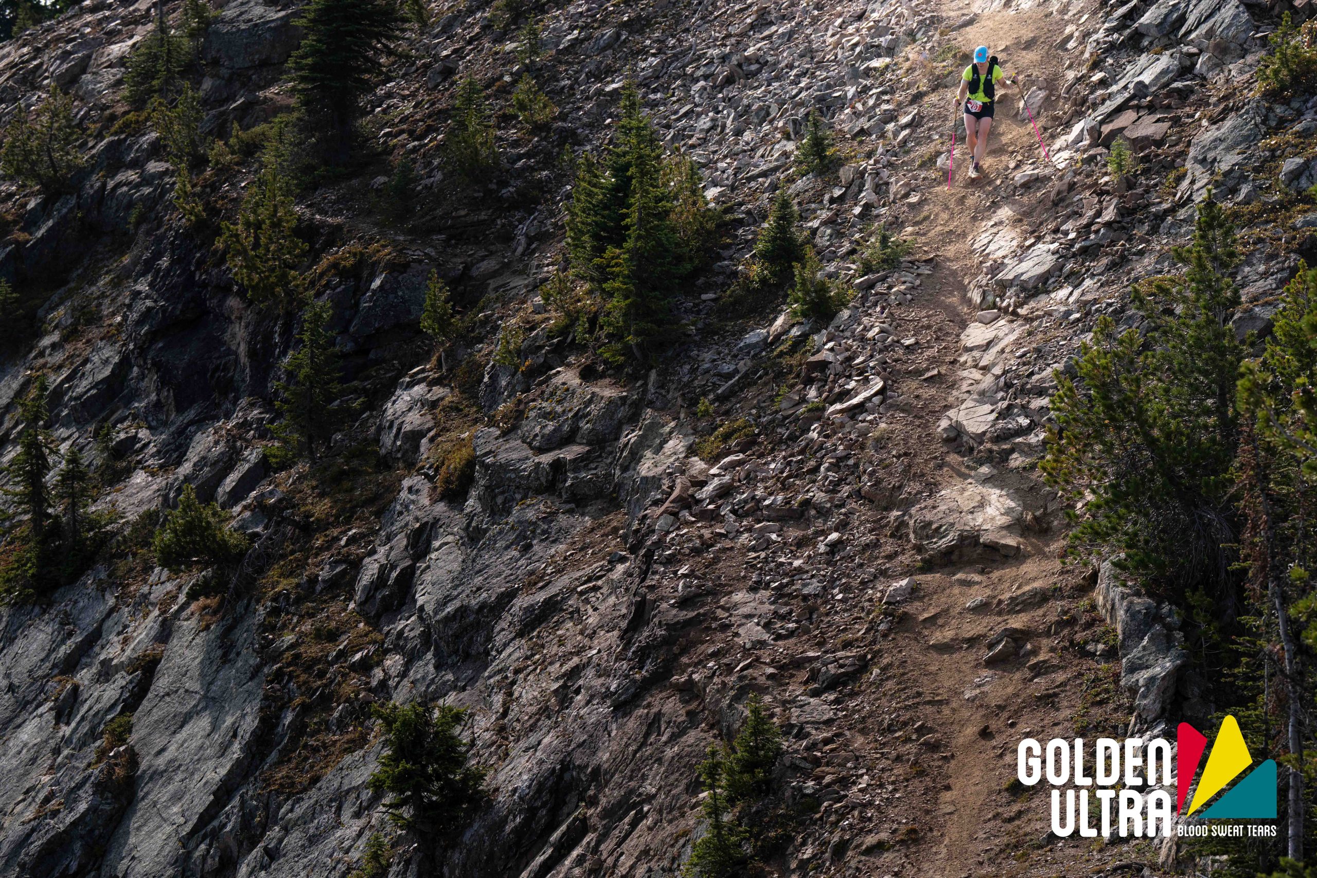
3. Course: The mountainous course is beautiful and challenging, and you get a little bit of everything: flowy single track through the forest, a technical, steep ridge climb to the top of the Kicking Horse Mountain Resort Gondola, and some quad busting descents.

Not so much – Aspects of the race that didn’t do it for you

1. Timing: From a participant perspective, it seemed like something went awry with the timing. When crossing the finish line, the zone4.ca updated your time automatically based on the chip you are wearing. Then, later in the day, all of the times had between 45 seconds to a couple minutes added to them. We were informed that this was an adjustment for gun time. This would seem fine, except for the fact that even with video evidence of crossing under the timing clock at a certain time, it was still off by nearly a minute. While it might not seem like a big deal, as it did not affect placements, for those of us who were aiming for a certain time and thrilled to squeak in just under, it was frustrating to not have that time be ‘official’. Why did we wear those bulky chips around our ankles then?!

2. Medal mishaps: They forgot to hand out medals for the 60K/30K racers. Oops! They have offered to mail them out though if we want it!

3. No watermelon? All I wanted was watermelon at the aid stations!

4. Drop bags: They only had drop bags available at one aid station (though runners visited it twice), which was at 7.5 miles (11 km) and 29 miles (47 km) into the race. I did utilize it, but it seemed too early/late in the race to need much. I would have preferred one 21 miles (34 km) into the race, at Aid Station 3, especially if I had no crew/supporters on course to help bring things.

Golden Ultra 60K Stage 2 course profile.
Highlights of your race – What did you do well and enjoy about your race in particular?
  1. Overall pacing: The Golden Ultra 60K was my first ultra, so I wasn’t too sure how exactly to pace for a longer race. In hindsight, I feel like I did go out a bit hot, but felt soooo so good up until the last 12k, when the temps hit 27oC (81oF) and the quads had had enough.
  2. Fueling: I am very happy with how fueling went for the most part. I had practiced hard for this, and it paid off!
Lessons for others – Share your pro-tips on the race to help the next runner

Bring a headlamp! The 6 am start isn’t too early, but it is dark at this time of year until around 7 am. You’ll need a headlamp to feel confident on the forest trails. The headlamp can be dropped at the first aid station if you’ve got a drop bag there.

Lessons you learned that will help you next time around

If I could go back and do it again, I would have slowed down for the first 6 miles. That said, it is very challenging to be on single track, with a group of people behind you, and not push a little more than you intend.

Most important course specific knowledge to know about the race

I think the most challenging part of the Golden Ultra 60K course is the final 12 km (6-7 miles). There are lots of little punchy climbs and descents that feel so challenging after pushing on the main climb/descent earlier on in the race. If you can manage your effort, or build your durability to withstand the last 12 km, you’ll be golden (I had to)!

Aesthetics – Is it a pretty course?

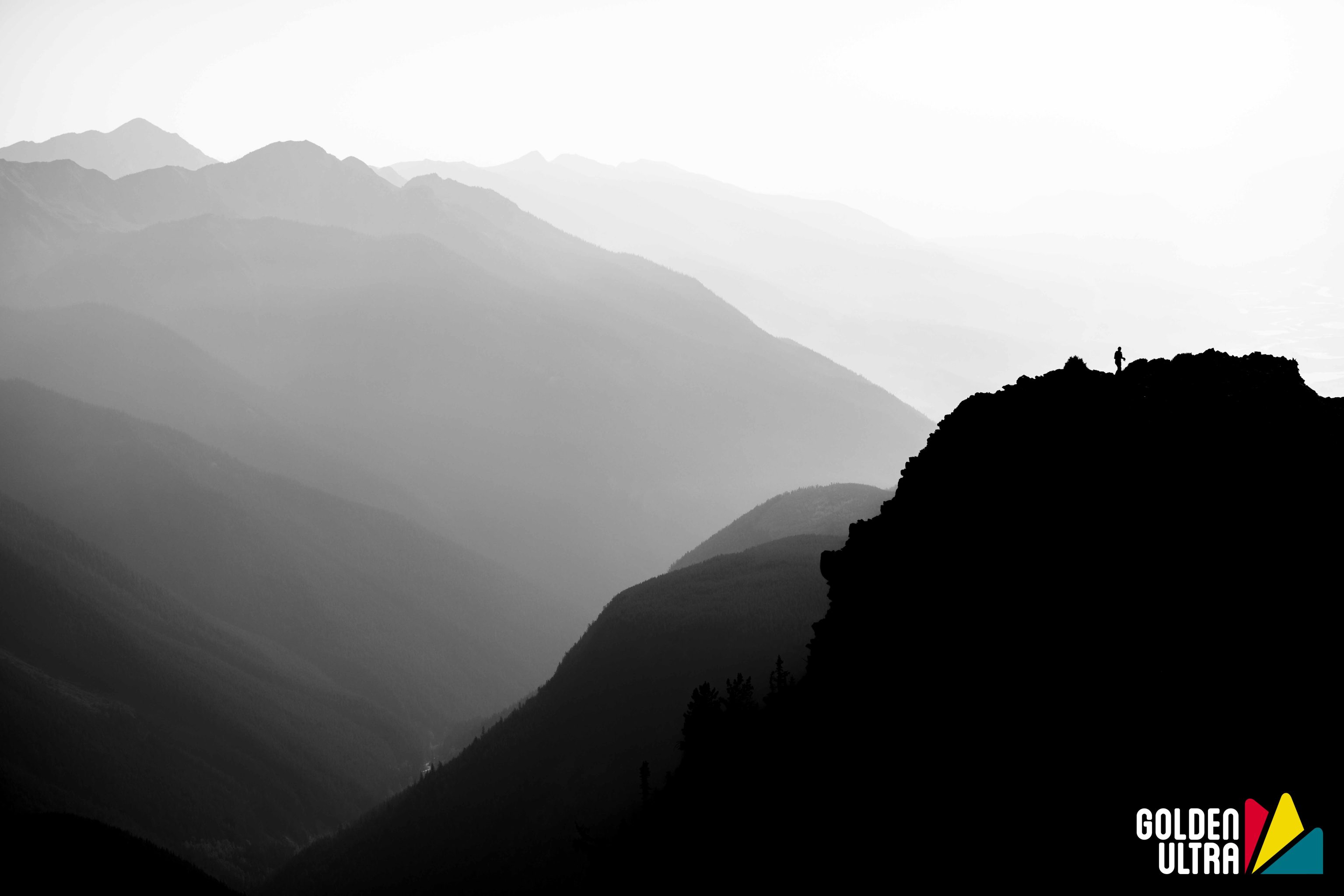
Beautiful! Unfortunately, some wild fire smoke had entered the area for the weekend. That said, it wasn’t too bad as we ascended into the alpine, and it gave the mountains a very moody feel (see picture below). The smoke cleared later in the day, and we were treated to some epic views at the top of the gondola. Running through the lower trails was also really enjoyable.

Difficulty – Is it a tough course?

Yes! The Golden Ultra 60K is ~59 km with 2500 m (or around 8200 feet) of vertical gain. The course progresses from rolling trails into one giant climb, followed by one giant descent, and then more rolling trails to the finish. There are a few sections that also require careful footing, such as the approach the aid station at the top of the gondola, and when descending the first section of the ski resort.

Jennifer Kozak descending a steep climb during the Golden Ultra 60K. PC: Jonathan McLeod
Organized and well run – Did it feel like a well-oiled machine or were they flying by the seat of their pants?

Everything (aside from the timing) seemed like a well-oiled machine. Package pick up/drop bag drop off was super smooth. Helpfully, race information was shared quite a few times leading up to the race via email or on the Golden Ultra Facebook forum. As mentioned above, the aid stations were incredible.

Competition – Is there a strong field?

Yes, there are some very strong runners in this race! People travel from all over to attend, but you’ll find the majority from in and around BC/Alberta.

A moody, early morning shot of the major course climbs. PC: Jonathan McLeod
Logistics – Does it require a special handshake, registration a year in advance, hotels all booked? Give us the low down on the nuts and bolts of making the race happen.

They usually have tiered pricing for the Golden Ultra event, so, if you are the first to register, you’ll get a cheaper price than if you book a month after registration opens. Because of this, they had a lot of traffic the first day of registration and it caused a few glitches. They worked hard to remedy this, and fixed any issues people had with their registration. The race itself did not seem to sell out though until a month or two before the actual race start. Accommodation was trickier as the town is quite small. If you stay at the resort (where a lot of the vacation rentals are), be prepared to be trained getting to the start line!

Aid Stations – Standard fare or anything special to know about the aid stations in terms of what’s available or when?

As mentioned above, these were the best aid stations! This was more so for the people than the food itself (which I barely ate any of). They had Xact Bars as their sponsored nutrition and F2C as their electrolyte. I knew neither of these would work for me, so I didn’t partake. And despite their lack of watermelon, they had seemingly everything else: oranges, grapes, cookies, candy, chips, pretzels, tater tots, bacon, quesadillas, and more.

Weather and typical race conditions

Last year, the weather was colder and quite socked in (perfect running temps)! This year, it was hot with a bit of smoke in the air. With it being a higher alpine environment, the weather can change very quickly: expect every type of weather from blazing sun to snow.

Gear – Did you need anything special or is there anything you’d recommend for the next runner?
Jennifer Kozak finishing her first ultramarathon. PC: Jonathan McLeod

They have a required gear list for the Golden Ultra 60K: jacket, gloves, toque/beanie, and emergency blanket. Bear spray is optional. Personally, I liked having poles for the major climb and tucked them away for the rest of the race after that. While it’s not on the required list, a headlamp is 100% needed for the first hour or so.

Spectators – Is this a friendly course for your friends?

Yes, there are quite a few spots to view. The first spot would be at the first aid station (I believe you can walk/drive in). The most popular spot would be at the top of the gondola. Spectators would need to buy a sightseeing gondola pass for the day from the resort, and make it up there to see your runner (and the views)! I was able to see my family at the top of the gondola (where they provided aid), at the bottom of the long descent down the ski hill, and again at the finish line.

How’s the Swag?

I loved it! Runners received a T-shirt (non-technical) and a metal cup branded with Golden Ultra at check in. Before the race start, the race director was handing out collapsible cups for use at aid stations during the race (which is great because I had forgotten mine). At the finish, a hard-earned medal (pending…see above) and pint glass await.

The Overall Score – How many stars do you give this race and do you recommend that others run it?

4.5/5! I loved the Golden Ultra 60K and would 100% run it again! My little annoyances of the race pale in comparison to the overall event and weekend, which was nothing but enjoyable. I would highly recommend any runner coming to BC to try one of these events!

Jennifer Kozak is a coach with Team RunRun who knows how to balance training with family, on both the roads and the trails. Jenn works with athlete of all abilities, from those dipping their toes in trail races or tackling new goals on the roads, from the 5k up to the marathon.

Ridge to Rails 50K Race Report

TRR Coach Tanner Amrhien after finishing the Ridge to Rails 50K.

Race: Ridge to Rails 50K Trail Race

Runner: TRR Coach Tanner Amrhien

Race Date: 06/07/2025

Location: Old Fort, North Carolina

Result: 5 hours and 57 minutes, 25th out of 112 runners

3 Bests – What aspects of the race did you like the most?
  1. Views: Enjoy incredible views of the Blue Ridge Mountains throughout the Ridge to Rails 50K.
  2. Aid stations: Well stocked, and really helpful, friendly volunteers!
  3. People: The trail running community is awesome! I met a plethora of great people, and we had great, far-reaching conversations along the way.
Not so much – Aspects of the race that didn’t do it for you

Not within anyone’s control, but the humidity from the start was high and hanging in the air!

Highlights of your race – What did you do well and enjoy about your race in particular?

I made sure to stay hydrated. This helped me avoid cramping and kept my body as cool as possible despite the hot temperatures and humidity.

Another highlight was setting a new 50K PR!! Sections of the course are on gravel and pavement, which makes for a fast race. The Ridge to Rails 50K course is one big loop: a true adventure through the Blue Ridge Mountains!

Lessons for others – Share your pro-tips on the race to help the next runner

Don’t linger at aid stations longer than necessary—get in and out quickly. Try to carry as much nutrition with you as possible. I was aiming for a sub 6-hour race and hit my goal with just three minutes to spare. Staying efficient at aid stations was key to making that happen.

Most important course specific knowledge to know about the race
Ridge to Rails 50K course map and elevation profile.

As mentioned above, the Ridge to Rails 50K course is one big loop on varied terrain. Expect a mix of smooth and technical trails, as well as sections on gravel and pavement. For example, roughly five miles of this race were uphill climbing on pavement, so you might want to reconsider your shoe choice if it’s not road-suitable.

Aesthetics – Is it a pretty course?

Such a beautiful course! The climbs were steep, but rewarded runners with amazing views of the Blue Ridge Mountains.

Difficulty – Is it a tough course?

With over 5700 ft of elevation gain and loss, it’s not the toughest course, but not the easiest either. The climbs were challenging, but are more gradual. Whereas the downhills tend to be relatively steep and fast: perfect for runners who excel at downhill trail running.

Organized and well run – Did it feel like a well-oiled machine or were they flying by the seat of their pants?

The Ridge to Rails 50K race was very well organized. The event company, Tanawha Adventures, puts on many races in Western NC throughout the year, so know how to do a great job!

Competition – Is there a strong field?

Yes, very strong. Many of the competitors live and breathe trail running throughout the Blue Ridge Mountains for everyday training.

TRR Coach Tanner Amrhien during the Ridge to Rails 50K.
Aid Stations – Standard fare or anything special to know about the aid stations in terms of what’s available or when?

The aid stations were a highlight of this race! For the Ridge to Rails 50K, there were 5 aid stations throughout, well stocked with everything you would’ve wanted while running an ultra. Alongside the standard fare offerings, there was cola, pickle juice, Snickers bars, candy, and more. The greatest thing about the aid stations during this race were the volunteers. They were quick to help you in and out of the aid stations, offering to refill your bottles and then send you off with a smile!

Weather and typical race conditions

The weather was partly cloudy and the humidity was intense! At the start, my watch caught an 89% humidity reading! It was warm too! The temperature reached about 85 degrees by the time I finished the race.

Gear – Did you need anything special or is there anything you’d recommend for the next runner?

I ran with collapsible poles, but ditched them at the mile 28 aid station. They worked great for the road climbing sections of the race. However, they were not a necessity for this race, and you may be better off without them.

How’s the Swag?

Great! Everyone receives a high quality race t-shirt, race sticker, and a unique, locally crafted finisher tile in place of a standard medal. The race organizers clearly care about their swag: it’s all really good quality and personalized for the event.

The Overall Score – How many stars do you give this race and do you recommend that others run it?

8/10 rating for the Ridge to Rails 50K. I would recommend others to run it who are moderately experienced with trail running.

Tanner Amrhien is a coach with Team RunRun based in Charlotte, North Carolina. He helps athletes improve performance through thoughtful training, science-based nutrition guidance, and injury prevention strategies.

Is Running An Ultramarathon For Me?

Runners smiling during an ultramarathon.

And why would I want to run an ultra when I hated the marathon?


For many endurance athletes (and if you’re reading this, I assume you are one of them) then the thought “Is running an ultramarathon for me?” may have crossed your mind. You also may have just as quickly dismissed it.

While road marathons and ultra distance races have similarities–tough training, events lasting several hours–they can almost feel like different sports.

Before I start, I have a confession: I have never run a road marathon. 26.2 miles on the road doesn’t appeal to me, and I decided to trust my doctor when he told me it was bad for my knees, so I haven’t. He didn’t say anything about ultramarathons though…

Ultramarathons can be kinder to your body

While “shorter” 50K ultras are only 10K more than a road marathon, expect them to take much longer if you go down the classic ultra route and choose to run on some form of trail.  Fortunately, on trails you avoid the jarring of the tarmac and the same repetitive stress from the same foot strike pattern. Instead, you’re exploring a variety of terrains, from lush forest trails and dirt roads, to rocky mountains and sandy beaches. Your body is constantly adapting to each surface, sharing the load across different muscles, joints and bones. Of course, there are road options available if you do love the road marathon.

What you’ll see along the way

If you hate running on pavements through urban areas (‘sidewalks’ for my American friends), then this is where ultramarathons shine. Take your pick of scenery, from stunning mountain ranges through to desert expanses. Again, if you actually don’t mind the tarmac, there are ultra distance road races. Just have a look at some of the coverage on YouTube of the big ultras and tell me that it isn’t stunning–all you have to do is remember to look up!

Two women running the Javelina Jundred 100-mile race in costumes. PC: Howie Stern

The ultrarunning community

Every race that you do will have some sort of vibe, but in my opinion, this is one of the most beautiful things about trail and ultrarunning. You get it all! Small community style races with weird and wacky traditions, to huge events with thousands of runners and festival style feel.  The Javelina Jundred and Lakeland 100 spring to mind for mad, festival-feeling ultramarathons.  Either way, I have found that everyone, aid station volunteers and fellow competitors included, just want you to do well and have a good time. Yes, they are ‘technically’ races but the competition side, certainly for us that are mid- to back-of-the-packers, doesn’t feel that important.  The sense of community and finding your tribe is a consistent theme I hear from all the ultrarunners I interview on my podcast

The supportive ultrarunning atmosphere at an aid station.

Because it’s hard

Are you looking for your next big running challenge? Running an ultramarathon is the way to go. While a 50K is no easy feat, it’s still something that most marathoners could do, it’s just the hook that reels you in! Finish your first 50K and you’ll then find yourself thinking: “I wonder if I could…”, and off you go, down the ultrarunning rabbit hole! Of course, ultras test you physically, but as the distance increases, the challenge becomes (at least) as much mental, and with that you also get to learn so much about yourself.     

Time is irrelevant for ultramarathons

If you have been running for a while then you might pick up on what a “good” performance is, from the world records to ‘good for age’ times. But for ultras, well nobody knows, and even if they did, I don’t think they’d care! People ask about the race distance not the time, joke that they don’t drive that far, look a bit confused then walk off (usually impressed). 

Ultrarunning camaraderie and enthusiasm during a race.

And on the subject of time, pure speed is less relevant than in road marathons. So much so that you may continue to see performance improvements well into your fifties (that’s what I am betting on). There is so much more to becoming a good ultrarunner than simply running, and that comes with experience.

David Taylor is a coach with Team RunRun based in Glasgow, UK. He specializes in trails and ultras for both beginner and intermediate runners, whether you’re just bumping up in distance or looking to improve your next trail race.

Ronda Ghibellina 45km Race Report

Race: Ronda Ghibellina 45km trail race

Runner: TRR Coach Keith Laverty

Race Date: 01/26/2025

Location: Castiglion Fiorentino, Toscana, Italy

Result: 4 hours and 43 minutes; 7th overall

Strava Activity Link: https://www.strava.com/activities/13456640095/overview

3 Bests – What aspects of the race did you like the most?
  1. Europe: This was my first time racing in Europe, so just about everything about the experience was novel and new to me. We even ran through a castle during the first mile!
  2. Challenging course: The challenge of the course and everything that it threw at us — which was a lot!
  3. Community kindness: Despite language barriers, the kindness of the Italian running community was memorable and much appreciated. It also seemed like many runners had traveled to this event from all other areas of Italy: this race welcomed everyone.
Keith Laverty crossing the finish line of Ronda Ghibellina 45km. PC: ENDUpix
Not so much – Aspects of the race that didn’t do it for you

Sort of a “blooper” on my end but I forgot to look up the phrase for “on your left” or “runner behind” in Italian, as I ended up needing to pass several dozen runners from the longer 67km distance that had started a couple of hours before the 45km. The word I had thought was “left” in Italian, actually had translated to “I want”, which I’m sure got me some puzzled looks on their faces! : )

A couple of points got bottlenecked on very tight section of trail, that had forced me to walk or slow down my effort such as during a down-climb with rope assistance.

Weird factor – What’s the weirdest thing about this race?

More unique than weird, is that the Ronda Ghibellina 45km race and entire event is all Medieval vibes! This included a man with armor and shield on a horse at the start/finish area. Then the finish line amenities of bread with olive oil, and beer poured into your finisher’s mug. There were supposed to be more horses out and about, but they had to put the horses away after the thunderstorm.

Highlights of your race – What did you do well and enjoy about your race in particular?

Overall, the highlight was working through the extremely challenging terrain, especially during/after the thunderstorm that sort of shook me up a bit (including hail that pelted the right side of my body). I even fell into large puddles within the same mile. Enduring through this race has put other courses into perspective, including upcoming races on my calendar have become known as “the courses aren’t nearly as rugged as Ronda was”!
I thankfully chose the right racing shoe, the Adidas Agravic Speed Ultra, to handle the ruggedness well, but also felt fast on the runnable road sections too. Final win: NO BLISTERS or foot issues!

Lessons you learned that will help you next time around

Next time, pack a light jacket! I was moments away from pulling out my emergency blanket, and obviously was not prepared well for the thunderstorm conditions that rolled through. This led to very frozen fingers and cold legs for several miles after. The forecast had only shown a 50% chance of rain for about 2 hours and no signs of thunder, however, as I’ve learned over the years too, conditions can change *fast* in the mountains.

Ronda Ghibellina 45km course map and elevation profile.
Most important course specific knowledge to know about the race
Some of the historic Italian scenery seen throughout the race.

During the first mile, there’s a steep, relatively long hill climb of 20%+ grade of paved road running through the castle. Then, besides the first and last 2 miles, the course only has 2 to 3 0.5 mile sections of runnable road/ forest road. The majority of the race is running through a wide variety of challenging terrain: steep downs on rocks, twisty/tight/muddy turns, down-climbing with a rope, grassy and muddy stretches, and leaf-covered trails. Some of the wooded sections seemed reminiscent of what you might see on the “Beast Coast” (aka trails on America’s east).

Aesthetics – Is it a pretty course?

Oh yes! You essentially run along the outer rim/ridges of a “bowl” or valley in between, completing one big loop around Chio Valley. After the first key climb, you get treated to the beautiful valley below.
The thunderstorm likely blocked some views mid-race, but once the skies had cleared and the sunshine arrived toward the last 5 miles, I was treated to an incredible view of the grassy, farmlands and hillsides below. You also get to run through villages, older ruins and ranches, and through oak and olive trees: not your typical US race views! Bellissima!

Difficulty – Is it a tough course?

I’ve competed in a lot of tough races in the last 20+ years, and I think I’d have to rank the Ronda Ghibellina 45km race in my top 5, maybe even top 3 most difficult courses!
The course profile alone is plenty challenging with 7,500 feet of climbing in 28 miles; however, a lot of those 28 miles were very technical, especially the descents. There were lots of uneven, slanted/grooved rocks, tight/windy turns. And as if that wasn’t enough, layers of mud caked the course following the mid-race thunderstorm, hail and rain!

Organized and well run – Did it feel like a well-oiled machine or were they flying by the seat of their pants?

Overall, it was very well-organized, including the pre-race expo and race day itself. Unfortunately, there was hardly any pre-race communication. With no pre-race email on any sort of details or instructions, it was difficult to find and understand their required gear list.

Competition – Is there a strong field?
Keith Laverty racing the Ronda Ghibellina 45km. PC: ENDUpix

The competition was world-class this year! In fact, the entire Italian national team decided to show up and this run this race as part of their early-season team training camp! I’m guessing that made for a significantly more field than usual this year. The men’s winner, 4x national champion Andreas Reiterer, won in a new CR, despite the muddy conditions!

I also found out that the majority of the runners who placed in the top 10 had all run the Ronda Ghibellina 45km in recent previous years, which speaks to how event keeps drawing runners back.

Logistics – Does it require a special handshake, registration a year in advance, hotels all booked? Give us the low down on the nuts and bolts of making the race happen.

The registration alone is simple and very affordable: just 45 Euros ($47 or £37) for a 28-mile course with 5 aid stations!

However, the Italian law is very strict on international runners who want to compete. Prior to the race you need the following tests completed, then signed off by your doctor: (1) EKG stress test, (2) pulmonary function test, (3) urinalysis, and (4) a basic physical exam. So allow for at least 10 weeks before the race date to make sure all of your appointments can be scheduled and completed in time. Simply put, it’s a much more in-depth process than signing a waiver!

Weather and typical race conditions

This is the coldest time of the year for Tuscany with average temps of high 30’s to the low 50’s (Fahrenheit). This year’s edition felt comfortable in the mid to high 40’s for race morning. However, a ferocious, crackling thunderstorm around mile 13 made things interesting to say the least! I went from racing mode to survival mode pretty quickly, dealing with pelting hail and rain showers for the next 4-5 miles!

Gear – Did you need anything special or is there anything you’d recommend for the next runner?

Nothing too special, although a long-sleeve jacket is highly-recommended in the event of a storm like we had! You’re also required to run with your phone, with their live tracking app, “Whip Live” opened (fortunately, it can be opened in the background and not burn through the battery).

Spectators – Is this a friendly course for your friends?

Not so much. There were 2 or 3 aid stations with more people, so it’s potentially more accessible for spectators if you’re willing to do a lot of driving.

How’s the Swag?

Cool swag! Each finisher received a large, ceramic mug with the race logo. We also got a black/army green tech running tee from the Runnek brand. At the pre-race expo, you could also opt to buy more race-branded gear such as a sweatshirt or a collapsible soup cup.

The Overall Score – How many stars do you give this race and do you recommend that others run it?

5 out of 5 stars!

The Ronda Ghibellina 45km was an incredibly memorable experience with the epic course, weather challenges, and friendly people. It was hard to turn down the opportunity to run in Tuscany, not to mention, exploring other parts of Italy before and after!

Keith Laverty is a Seattle-based coach with Team RunRun. Whether you are heading towards your first 5k or – like Keith – in your ninth year of ultras, Keith will design a custom training plan based on your goals, lifestyle, skills, and needs.

Bold Coast Bash 50K Race Report

Team RunRunner Chris Manwaring persevering through the Bold Coast Bash 50K.

Race: Bold Coast Bash 50K

Runner: Chris Manwaring

Race Date: 11/10/2024

Location: Cutler, Maine

Result: 9 hours 43 minutes and 25 seconds

3 Bests – What aspects of the race did you like the most?
  1. Taking in the views: Sunrise hits at about the time that you reach the first ocean cliffs and it lights up the course beautifully.
  2. Challenge: This is very typically a lot of people’s (including myself) last ultra for the season. The year has been long and the generalized fatigue is real. The mental well isn’t quite as deep as it was back in May. It is an objectively challenging course as it is, but made even harder by its timing when overall burnout is at its highest.
  3. Volunteers: So many folks turn out to make the Bold Coast Bash 50K happen and they are the best!
Highlights of your race – What did you do well and enjoy about your race in particular?

I did well balancing my running and hiking ratios. I knew I could string together longer running sections (~15-20 strides each) on the inland single track, and made sure to take advantage of that before having the break it up with a half dozen hiking strides to navigate a technical section. Then I’d hit another more runnable section and repeat this sequence. This was an area I identified last year as needing improvement, as I was more apt to just straight hike those sections, which led to me timing out at mile 22 and DNFing.

Lessons for others – Share your pro-tips on the race to help the next runner

The Bold Coast Bash 50K is a 3 lap course with time limits for each. Racers have 6.5 hours to finish their first two laps, for an average of 3.25 hour laps. The total time cut off is 10.5 hours, so if you come in around 6.5 hours for the first 2 laps, you have 4 hours to complete the final one.

Lessons you learned that will help you next time around

Being confident with starting out my race feeling a little cold was a big lesson this race. With the temps starting at ~30 degrees and projected to climb into the 40s before I would finish my first lap, I knew if I started warm and comfortable, I’d be too sweaty and hot midway through the lap. I ended up starting with shorts, a t-shirt, light gloves and sun sleeves on, and although I was cold for the first 20 minutes, the next two and a half hours I was moving and keeping a comfortable temperature.

Most important course specific knowledge to know about the race

It is classic New England technical terrain. Generally folks move faster on the single track inland versus on the rocks and cliffs along the water. The course follows a figure-8 pattern so it’ll end up alternating single track/cliff sections.

Aesthetics – Is it a pretty course?

Without a doubt! I think one of the biggest draws of this course is just how beautiful it is. The single track trail winds through some wonderful woods, and the coastal route takes you inches from the edge of steep cliffs with endless ocean views. On the southern end of the course, the buoy moored offshore from a nearby lighthouse can be heard clanging in the distance. The waves crashing against the rocks and cliffs become familiar sounds, fading into just a soft rush as you run along the stony beaches. It is a remote and gorgeous place that I’ve heard described as a “wilder, quieter Acadia”.

Difficulty – Is it a tough course?

The Bold Coast Bash 50K course is deceptively tough. There is about 1700 ft of elevation per 10.5 mile lap. It is constant PUDs (pointless ups and downs) with lots and lots of roots and rocks like any New England technical trail would have. With such variation in the ground underfoot, it is difficult to fall into a cadence or rhythm. This race has a decent DNF rate for its distance for a reason!

Organized and well run – Did it feel like a well-oiled machine or were they flying by the seat of their pants?

The race is extremely well run. Eric, the race director (RD), does a really great job of ensuring efficient infrastructure around the start/finish line and aid station and recruits countless volunteers to help out. Course marking is fantastic: it’s reassuringly difficult to get lost and wander off a cliff!

Gorgeous views Chris saw during the Bold Coast Bash 50K.
Competition – Is there a strong field?

The competitive field is pretty good for a race in northern Maine! The Bold Coast Bash 50K attracts plenty of fast local runners as well as folks from farther away.

Logistics – Does it require a special handshake, registration a year in advance, hotels all booked? Give us the low down on the nuts and bolts of making the race happen.

This is a high demand race with limited spots! Registration generally opens August 1st on UltraSignup: the 10.5 mile fun run option generally sells out within a few hours, and the 50K distance generally sells out within a few days. Waitlists are long but can also move quickly! In terms of lodging, the race offers a limited number of racers to camp about 600 ft up the road from the start/finish line which is a blast! I would recommend bringing extra blankets and hoping for a clear sky because the stars pop out there! It is usually split with some folks out in tents (like me!) and others in vans and things like that. The closest Airbnbs are about a half hour away from the start/finish line in either Machias or Lubec if one prefers!

Aid Stations – Standard fare or anything special to know about the aid stations in terms of what’s available or when?

There is a single aid station located at the start/finish line accessible between laps. It is well stocked with plenty of options, including gluten free and vegan item. That said, generally hot food isn’t ready until after one finishes their second lap. Runners are encouraged to bring a food item for the aid station to share with fellow competitors. Electrolytes this year were packets of LMNT that the aid station volunteers were great about mixing in my flask for me. My personal favorite offering this year was the venison chili, although it was almost as good as the bear meat chili featured at last year’s race.

Weather and typical race conditions

It’s November in northern Maine… expect basically anything. This year the race started off at about 30 degrees and rising up to the mid 40s, but dry! Prior years have seen snow and ice, lots of mud, and summer conditions.

Gear – Did you need anything special or is there anything you’d recommend for the next runner?

If particularly cold conditions present themselves on race day, additional items are added to the required gear list. Otherwise, a strong pair of trail runners that performs well in/on mud, ice, and wet rock are essential!

Chris midway through the Bold Coast Bash 50K.
Spectators – Is this a friendly course for your friends?

The start/finish line (and aid station) is the best spot to see runners coming in on laps. The course is also open to the public during the race, so spectators could hike part of the course to try and see their runner.

How’s the Swag?

Swag is great! Eric, the RD, does a really great job finding cool non-t-shirt swag and mixes it up every year! This year we received reflective vests, last year quarter zips, and the year prior fleece blankets!

The Overall Score – How many stars do you give this race and do you recommend that others run it?

5 out of 5 stars for an unparalleled course in terms of scenery, a challenging technical day, and with lots of friendly Mainers volunteering!

by Chris Manwaring

For more popular Maine ultra trail races, check out “Riverlands 100 Mile Race Report – Bucky Love” and search for “Maine” under “Popular Post Tags” on our blog.

Sun Mountain 50K Race Report

Race: Sun Mountain 50K

Runner: Rohit Eipe

Race Date: 05/18/2024

Location: Winthrop, WA

Result: 9:57:12.9 https://chronokeep.com/results/sun-mountain-50/2024/570

Strava Activity Link: https://www.strava.com/activities/11443014175

3 Bests – What aspects of the race did you like the most?

  1. Scenery – the mountain vistas, meadows of spring flowers; the area makes me want to leave the city and retire there!
  2. Trail conditions – generally pretty easy trails without too many roots or rocks. The course is singletrack trail for most of the race, with some wider sections.
  3. Aid stations – while they could be better by having consistent items at each aid station and publishing precise lists of what to expect ahead of time, the aid stations were well staffed, well stocked, and full of friendly race support. Having drop bags at each aid station made it so that I could changes socks often, change shoes for road and trail sections, carry less food and water with me, have my specific preferred fuel – so kudos to the race folks on organizing these well and getting everything right here.
  4. Weather – it was pretty wild at altitude, which made things harder, but it was cool and generally good running weather… plus the hail certainly made for a good story!

Not so much – Aspects of the race that didn’t do it for you

Overall race organization – the organizers of the Sun Mountain 50K and the weekend’s other races changed the course after months of my (and probably many other folks) emailing them to understand what the course was, which meant I didn’t know what I was training for. Eventually they added 10 miles of pavement – which I had mixed feelings about personally given I was expecting a trail race. I’m so used to road running and was looking forward to the added challenge, but those extra pavement miles made the race much more doable for me in the end. I could see this being very annoying for other folks set on a trail run too.


Weather – I got hailed on at altitude for about 6-7 miles, which in fairness we were warned about. In the end, it was actually kind of fun, but I can see how this isn’t everyone’s cup of tea. You also can’t control for that though.

Weird factor – What’s the weirdest thing about this race?

Definitely the weather! There is always a huge variation based on altitude primarily, and May is also shoulder season so it could be hotter or cooler depending on the year. For me, on the day it went from sideways hail to light/heavy rain to sunny and baking sun: basically all four seasons in one day!

Highlights of your race – What did you do well and enjoy about your race in particular?

Finishing – I’d DNF-ed at a 50K 7 years prior, so for me this was a grand f-u to the universe and I’m stoked to have finished! Spite is the best motivator!
The scenery was also a highlight, as I mentioned about. The town of Winthrop had a really nice vibe to it as well.

Lessons for others – Share your pro-tips on the race to help the next runner

Use the drop bags and carry less stuff! And for me, using poles was a good tool to take a ton of weight off my legs and made it possible to finish, so others could consider that too.

Lessons you learned that will help you next time around

I think I left a fair bit of energy on the table. I ran the last mile or so quite fast in the end, so I really should have sped up more on the road downhill at a bare minimum. I’d say the same for the gentle trail downhills: I should have pushed harder on those.

Also, my watch was in a mode that auto-paused the workout while I was at one of the aid stations for a good 7-8 minutes, resulting in a difference between chip time and my watch’s timing. I need to turn that feature off for races.

Most important course specific knowledge to know about the race

The course is mostly single track trail, but, based on permitting difficulties, it looks like road sections may continue to be a part of this race in the future. While for the 50K or 50M this isn’t such a big deal, it is a bit of a downer for the 25K if you end up running 10 miles of road and only 5-6 miles of trail. Be mindful that the aid stations are well spaced out, so use them. And remember that the weather can vary a lot based on altitude and luck of the draw!

Aesthetics – Is it a pretty course?

Very much so, one of the nicest courses I can remember!

Difficulty – Is it a tough course?

I didn’t think the Sun Mountain 50K course was super difficult, but there was a moderate amount of elevation for the distance. The singletrack trail meant you had to pay attention somewhat. There were very few steep sections, and even those were relatively mild.

Organized and well run – Did it feel like a well-oiled machine or were they flying by the seat of their pants?

Yes – except for the months leading up to the race with the permitting and course mess.

Competition – Is there a strong field?

I’m at the back of the pack here so I have no idea!

Logistics – Does it require a special handshake, registration a year in advance, hotels all booked? Give us the low down on the nuts and bolts of making the race happen.

Hotels and Airbnb’s probably fill up quite quickly, so book early.

Aid Stations – Standard fare or anything special to know about the aid stations in terms of what’s available or when?

Good on the whole, but they could be improved by publishing precisely what will be at aid stations ahead of time and sticking to it. I did discover peanut butter and pickle wraps, which were weird and delicious!

Weather and typical race conditions

As you’ve read above, expect widely varying weather! There could be snow and hail at the higher altitudes, and rain is very likely at some point.

Gear – Did you need anything special or is there anything you’d recommend for the next runner?

Poles are good but not really necessary. And I feel like pretty much everyone was running in the Hoka Mafates, so perhaps a shoe worth checking out for this race.

Spectators – Is this a friendly course for your friends?

Not this year based on the big changes to the course, and there was no racer crew support. This was a huge bummer.

How’s the Swag?

Not great. T-shirts were available for purchase but I didn’t buy one.

The Overall Score – How many stars do you give this race and do you recommend that others run it?

I’d give the Sun Mountain 50K 4 out of 5. It could be 5 with better organization.

Looking for your next goal race like Rohit? Check out this article: “How to Choose your next Goal Race“.

marine corps marathon race report

Marine Corp Marathon and 50k Race Info

Summary: The Marine Corp Marathon and 50k are run in the Fall each year in Arlington, VA, usually bringing large crowds and fairly unpredictable weather, but the energy of the races and the finish line are unforgettable.

Lessons Learned from Race Reports

  • Expect crowds throughout the race weekend – from packet pickup, to transportation, to the race. Lots of runners and spectators throughout
  • The race ends with .2 miles of uphill, so be mentally prepared
  • Even with it being in late October, temps can still be quite warm
  • If you train on relatively flat terrain, the course will likely feel hilly
  • It can be a fairly emotional race given the ties to the Marines, especially mile 12, the Blue Mile, which honors fallen soldiers
  • Getting to the start on public transportation can be tough with so many people trying to use transit and with it not starting very early in the morning
  • It’s a fairly long walk from public transportation to the runner’s village and start corral – about 1 mile
  • Miles 18-20 of the marathon can get a bit lonely, while the rest of the course is quite crowded
  • While there is an overall cutoff time, there are a couple of cutoff times throughout the race as well, where they’ll direct runners a different way and not give an official finish time

Course

Type: Point to Point with one big loop and several out and backs within the bigger loop

Start/Finish Info: The 50k course will follow the marathon course across the Key Bridge and divert at mile 4.5 for an out-and-back along Canal Road. There, the 50k course rejoins the marathon and continues onto the finish at the Marine Corps War Memorial. 

Hills: Biggest hill is in the first 2 miles, gain of ~200 feet; total gain of ~900 feet in the marathon

Course Maps/Elevation

Aid stations

13 water points and 11 aid stations for the 50k, and the marathon shares all but the first of the 50k’s water and aid stations. Water and Gatorade at each stop.

Oranges at mile 7, Honey Stingers between miles 12 and 13 and near mile 23, and Jelly Belly Sports Beans around mile 19

Spectator access

Locations and tips

Boston qualifier?

Marathon – yes

Race reports

https://trr.chadswork.com/marine-corps-marathon-race-report-navindra-g/

https://paulrobichaux.com/2018/11/03/race-report-2018-marine-corps-marathon/

http://www.runningonhappy.com/2017/10/marine-corps-marathon-race-recap-2017/

http://www.mollyonthemoveblog.com/the-marine-corps-marathon-my-experience-review-of-the-race/

https://www.bibrave.com/races/marine-corps-marathon-reviews

https://theaccidentalmarathoner.com/race-recap-2017-marine-corps-marathon/

Strava links

https://www.strava.com/running_races/2156

Race Website

https://www.marinemarathon.com/events/marathon

Running your first race? Check out our first-time runner checklist!

Javelina Jangover Night Runs Race Info


Date

9/28/19

Location

Fountain Hills, AZ

Avg Temps f.

93/70

Gain/Loss in ft

800ft per 25k

ft/mile gain

51.6

Highest Elev.

~2500ft

Start

7:00PM – 75K

7:15PM – 50K

Surface

Trail

Time Limit

7:00am general cutoff

Sunrise/set

6:15pm/6:20am

Furthest Aid

~8.5miles


Summary: Another popular Aaravaipa race in McDowell Mountain Regional Park, offering several distances, including 75k, 50k, 25k, 15k, and 7k, running on rolling desert single track trails with faster, smooth sections, some rocky sections, and old jeep trails. Races are stagger started, with the 75k starting first at 7pm. Races are multiples of the 25k Pemberton Trail Loop, with about 800 feet of elevation gain and loss per 25K loop. Runners switch directions each loop.

Lessons Learned from Race Reports

  • Have a good headlamp (that’s completely charged!) considering your entire race will be in the dark. Seems like a no-brainer, but lots of race reports talk about headlamp issues. Have a backup at the start/finish.
  • It’s a gradual climb up to the aid station in the middle of the loop and is enough of a climb to be noticeable but still runnable, especially if you’re running more than one loop
  • Some sections are smooth but others are quite rocky, enough to easily fall if you’re not paying attention
  • Considering it’s all in the dark, be mindful of course markings, especially if you’ve never run the course before
  • Expect temps to still be in the 80s even after the sun goes down
  • If it rains, once it stops, it’s likely to be very humid
  • Likely to see snakes, scorpions, spiders, etc and hear coyotes
  • Leave plenty of energy for loops 2 and 3 if you’re running more than the 25k
  • The hills will seem bigger and bigger on each ensuing loop as you get more tired and the longer you run in the dark
  • Be careful not to linger too long in aid stations – they have great aid stations with lots of food options, but the time can also add up!

Elevation

Total gain/loss: 800 ft gain/loss per 25k loop

Ft/mile gain: 51.6

Total climbs: Each loop consists of one main climb and one main descent of ~700 feet

Course Map/Elevation profile (CalTopo of 25k loop)

Aid stations

Total aid stations: 2 per loop, one at the start/finish and one about 8.5 miles in for loops 1 and 3 (75k), around mile 21 for loop 2 (50k and 75k).

Furthest distance apart:  ~8.5miles

What’s available: Standard aid station fare, along with plenty of ice given warm conditions are likely – water, ice, electrolyte drinks, salty and sweet snacks, fruit, pb&j, hot foods and more.

Crew access

Access Locations: At start/finish only at the Pemberton Trailhead Staging Area

Pacers

For 75k race only on loop 3

Race qualifiers

50K & 75K distances – 2 UTMB points.

Race reports

http://running.teamwoodall.com/races/2016-2/javelina-jangover/

http://delsalt.blogspot.com/2016/09/javelina-jangover-50km-night-race.html

http://christarzanclemens.com/2014/09/running-through-a-jangover/

Strava activities and GPX files

https://www.strava.com/activities/1876042264

Race Website

https://www.aravaiparunning.com/insomniac/jangover/

Vertigo Night Run Race Info

Summary (from the race website): All races are held on the 6.5 mile (10.4 kilometer) Sonoran Competitive track loop. The 31K runners will complete 3 loops, while the 52K ultra division will complete 5 loops, passing through the start/finish line after each lap! The Sonoran Loop offers a variety of obstacles to test runners skills. The track consists of steep inclines, swooping turns, technical descents, and rugged terrain.

Lessons Learned from Race Reports

  • Cupless event – bring your own bottles
  • Have cash for the parking fee in the park
  • Though it’s not a lot of ft/mile gain, the course looks like it’s never flat, with one really steep ascent of ~175 feet on each loop
  • Expect hot temps even after the sun has set, likely in the 80’s
  • With it being a loop course, have a strong mental game because it’s so easy to quit since you pass the start/finish so often
  • Course is a big mix of runnable, faster sections, short and steep ascents and descents, sandy washes, and technical sections. Be ready to adapt and try to avoid being frustrated if you can’t find a good “flow”

Elevation

Total gain/loss: 1197/1197

Ft/mile gain: 62

Course Map/Elevation profile

Aid stations

One remote aid station on each loop (~4.15 miles into course) in addition to the start/finish line (every 6.5 miles). The Far Side Aid & main aid stations will be stocked with water, ice, electrolyte drinks (Gnarly & Gatorade), salty and sweet snacks, fruit, pb&j, bean rollups, hot food (quesadillas, grilled cheese), and more.

Crew access

Allowed at start/finish of each loop (every 6.5 miles)

Pacers

None for 31k race

Race reports

http://koreykonga.blogspot.com/2014/08/vertigo-night-runs-31k-race-report.html

Strava activities and GPX files

https://www.strava.com/activities/1121346815

Race Website

https://www.aravaiparunning.com/insomniac/vertigo/

wyeast howl 50k

Wy’East Howl 100k and 50k Race Info

Summary: Wy’East Howl 100k and 50k are on the super scenic, runnable singletrack trails on the slopes of Mt. Hood, with plenty of vert to challenge runners in both events. New for 2019, the 100k course is an out and back starting and finishing at Mt. Hood Meadows Ski Resort, while the 50k is a point to point, starting at Rim Rock and finishing at Mt. Hood Meadows (new 50k course in 2019, about 1,500 feet less climbing).

Lessons Learned from Race Reports

  • Typical weather is warm and sunny but 2018, the inaugural year, saw rain, fog and chilly temperatures, so be prepared. Several race reports talking about being very cold for a lot of the race and not being able to stop long at aid stations because they were so chilly.
  • New course for 50k in 2019 – less elevation gain of 6,500 vs. 8,000 in 2018
  • Course descriptions on race website note creek crossings – be prepared for wet feet and possibly have shoes in your drop bag if you think this will bother you

Elevation

Total gain/loss:

100k: 11,600/11,600

50k: 6,500/5,100

Ft/mile gain:

100k: 187 ft/mi

50k: 210 ft/mi

Total climbs:

100k: 6 main climbs of ~1,000-1,500ft, with the longest and most gain from miles ~7-14 and ~37-44

50k: 3 main climbs of ~1,000-1,500ft, with the longest and most gain from miles ~6-13 and ~25-30

100k Course Map/Elevation profile

50k Course Map/Elevation profile

Aid stations

Total aid stations:

100k – 9

50k – 4

Furthest distance apart: 7.6 miles

Locations:

100k: Miles 7.4, 11.6, 18.4, 26, 31.3, 36.6, 44.2, 51, 55.2 (Bold = Crew access)

50k: Miles 5.5, 13.1, 20, 24.2

What’s available: Not noted on website – prepare for typical aid station fare of salty and sweet, soda, water, and plan accordingly if you need something special. Drop bags are allowed at several aid stations.

Crew access

Access Locations:

100k: Miles 7.4, 26, 36.6, 55.2, and start/finish. Miles 7.4 and 55.2 are the same aid station (Bennett Pass), and 26 and 36.6 are the same as well (Surveyor’s Ridge)

50k: Miles 24.2 (Bennett Pass) and finish at Mt. Hood Meadows. Not enough parking at Surveyor’s Ridge (mile 5.5) for 50k crew.

Crew instructions/directions: Limited parking at aid station at miles 26 and 36.6 for 100k runners (Surveyor’s Ridge) and 50k crew are asked to not go to that aid station because of parking.

Pacers

None

Race reports

Frank Fisher’s 2021 100k Race Report

Rob S’s 2018 50k Race Report

https://runoregonblog.com/2018/10/30/race-recap-inaugural-wyeast-howl-50k/

Race Website

https://www.daybreakracing.com/wyeast-howl/

Worlds End Ultramarathon Race Info – 50k

Date

6/1/2019

Location

Worlds End State Park, PA

Avg Temps f.

76/54

Gain/Loss in ft

5,915/5,915

ft/mile gain

191

Highest Elev.

~2,000ft

Start

7am

Surface

Singletrack/double track

Time Limit

12 hours

Sunrise/set

5:34am/8:34pm

Furthest Aid

6 miles


Summary: The Worlds End 50k is a rugged trail race featuring a 31.4 mile single loop trail on 98% single-track/double-track. With an elevation gain of 5,915 ft, it may not seem intimidating, but it has relentless climbing and descending with lots of technical trail to maneuver. Runners will have to run over rock fields, narrow and uneven terrain, steep climbs and a cliff side trail. Both a 50k and 100k distance are offered.

Lessons Learned from Race Reports

  • Relentless ups and downs and technical trails with lots of rocks and stream crossings
  • If it’s raining or wet, the rocks will be extra slippery
  • Likely chilly at the start but it will warm up quickly – take that into consideration for race day clothing and layering, and/or changing with drop bags
  • Being PA in June, weather is likely to be muggy with possible rain/thunderstorms
  • First big climb around mile 3 has lots of boulders to climb along the way
  • While a lot of the course is rolling with technical underfoot, some sections are runnable, so take advantage of them when you can
  • Expect a long day – most finishing times are around the same as a fast 50 miler finish
  • Really easy to drop at mile 19.3, as it’s near the Start/Finish, so if you’re tired and tempted, get out of that aid station and keep moving!
  • Use caution on the steep downhills with either loose rock, slippery rocks, or when they’re on the mountain side with a drop off on one side
  • Mostly runnable final downhill in the last 4 miles, but there’s also a really steep downhill section cut into the mountainside that can be pretty tough if you’re scared of heights or not used to steep downs.
  • Rather than hoping for more runnable sections, expect almost none so that it’s a pleasant surprise when you can run!
  • Pay attention to course markers – with such technical trails and so many power hiking sections, you might be looking down a lot and missing them.

Elevation

Total gain/loss: 5,915/5,915

Ft/mile gain: 191

Total climbs: ~9 climbs of 400-800 feet, countless other rollers and smaller gains

Course Map/Elevation profile

Aid stations

Total aid stations: 6

Furthest distance apart: 6 miles

Locations: Miles 4.3, 10.3, 15.9, 19.3, 22.2, 27.7

What’s available: Typical aid station fare; bring your own food if you have special needs/allergies

Crew access

Access Locations: Miles 10.3, 19.3, 22.2

Crew instructions/directions: Found in Participant Guide

Pacers

None (for 50k)

Race qualifiers

None

Race reports

http://philadelphiatribaby.blogspot.com/2016/05/worlds-end-ultramarathon-50k-2016-race.html

http://www.briankunkle.com/2016/05/worlds-end-ultramarathon-50k-race-report.html

https://bonktothefinish.com/blog/worlds-end-50k-race-report.html

Strava activities and GPX files

https://www.strava.com/activities/1019731068

Race Website

http://worldsendultra.com/

Mendocino 50k Race Info

Date

4/20/19

Location

Big River State Beach, Mendocino, CA

Avg Temps f.

57/43

Gain/Loss in ft

4980/4980

ft/mile gain

161

Highest Elev.

~1,000ft

Start

7:30am

Surface

Trail, fire road

Time Limit

9.5 hours

Sunrise/set

6:31am/7:58pm

Furthest Aid

6.1 miles


Summary: Now in its 4th year of running and Mendocino County’s first ultra marathon, the Mendocino Ultra 50K is a scenic and yet challenging course, starting and ending at the Big River State Park just south of Mendocino Village, featuring River, Ocean, Redwoods, and Waterfall, as advertised by the race. The course is a loop course, this year being run in the counterclockwise direction, which is different from 2016 and 2017 and some Strava runs found below – keep that in mind when reading race reports (2018 was counterclockwise).

Lessons Learned from Race Reports

  • Weather in the past has been cool, cloudy and misty at the start, warming up a bit throughout the day
  • Most of the climbing happens from miles 10-24, so be sure not to go out too hard on the easier 10 miles to start, and leave something for the last ~7 miles
  • Water crossings along the way, some without bridges, so be prepared for wet feet around miles 14 and 23
  • Long downhill from miles ~18-23 can wear on you, especially if your legs are tired from the 2 previous climbs
  • In that long downhill, some short, steep dips and climbs in drainage ditches, so be prepared that it’s not continuous downhill and be ready for the short, quick, pop-ups
  • Could see day hikers out in the final ~5 miles, so be prepared to share the trail
  • In the final miles, you have a rope-assisted descent, which is super steep, followed by a steep incline up. Volunteers should be there to help, but be ready for this near the end!
  • Long climb from 14-18 gains the most from 14-16, but then has lots of false summits until mile ~18
  • If you’re running clockwise, the rope course descent and ascent can clog up the traffic and cause a backup of runners.
  • No crew allowed, but drop bags are allowed at mile 16.5 if you need anything along the way
  • Lots of race reports talk about going into the race thinking it would be fairly fast, and then getting humbled by the middle climbs and the final miles. Know that the climbs are challenging, there are plenty of rollers along the way, and start out conservative enough on the first 10 “easy” miles

Elevation

Total gain/loss: 4980/4980

Ft/mile gain: 161

Total climbs: 3 major climbs of 600-800 feet, from miles ~10-12, ~14-16 (with rolling climb up to 18), and ~23-24

Course Map/Elevation profile

PDF of course map/elevation profile

Aid stations

Total aid stations: 5

Furthest distance apart: 6.1 miles

Locations: Miles 4.8, 10.4, 16.5, 22.4, and 27

What’s available: Oranges, bananas, pb&j sandwiches, gels, potato chips, sport drink, water, Newman O’s, coca-cola. (All runners will receive a re-usable ultraspire collapsible cup in their race bag–please pack with you on the run!)

Crew access

Access Locations: None

Crew instructions/directions: See start/finish directions


Pacers

None

Race qualifiers

None

Race reports

https://freeradical.me/2016/04/24/mendocino-50k-an-all-vegan-visually-stunning-race/ (lots of pictures)

https://thewholegeek.com/2018/04/30/mendocinocoast50k_2018/

http://www.saltyrunning.com/tag/50k-race-report/

https://mudsweatandpeers.com/2016/04/29/mendocino-coast-50k-a-beautiful-beast-of-a-run/

Strava activities and GPX files

https://www.strava.com/activities/953666898/overview

https://www.strava.com/activities/955038318/overview

https://www.strava.com/activities/555540006/overview

Race Website

https://mendocinoultra.com/

marin ultra challenge 50

Marin Ultra Challenge 50k/50m Race Info

Summary: Starting and finishing at Rodeo Beach, all three distances of the The Marin Ultra Challenge, the 25k, 50k, and 50m, all feature lots of challenging elevation changes. The races have a range of terrain, from exposed fire-roads to technical single track in the redwood trees. Super beautiful scenery if the weather is right, with great course support.

Lessons Learned from Race Reports

  • Must start the race with a headlamp and pick one up again if you think you’ll run past 6:30pm
  • Beautiful race but the elevation change is no joke, not just the gain, but the downhills as well, as you’re constantly going either up or down, some sections more runnable than others
  • Trail may be a bit congested at the start with both 50k and 50m starting on an uphill, with some sections with stairs
  • Climb in the middle of the race for the 50 milers up to Willow Camp is the most challenging – steep without switchbacks and have to run some roads out of Stinson Beach to get to the trails again
  • Likely lots of day hikers out on the trails, so be aware of other trail users and pay attention to course markings since hikers are going different ways, and there’s a point which the 50m and 50k split
  • Even though the courses have main climbs and descents, that doesn’t mean there won’t be smaller climbs and descents along the way
  • If it’s wet and windy, that can be especially challenging, as a lot of the course is exposed and not in the trees
  • Bring a change of clothes for afterwards, especially if there’s any moisture, as you’ll cool down fast
  • Weather likely to change a lot leading up to the race, so have options, especially layers, for the day of

Elevation

Total gain/loss: 10,550/10,550 (50m), 6300/6300 (50k)

Ft/mile gain: 211 (50m), 203 (50k)

Total climbs:

50m: 9 main climbs and descents ranging from 600-1800 feet with 3 climbs of 1,000+ feet and 1 climb of 1800 feet

50k: 6 main climbs and descents ranging from 500-1100 feet with 1 climb of 1,000+ feet and 4 climbs of over 600 feet

Course Maps (both) Miles 1-15 and 39-50 and Miles 15-39 /Elevation profile (both)

Aid stations

Total aid stations:

50m: 9

50k: 5

Furthest distance apart:

50m: 6.6

50k: 6.9

Locations:

50m: Miles 5.8, 10.5, 14.7, 19.8, 23.4, 29.3, 35.9, 40.8, 45.8

50k: Miles 5.8, 10.5, 14.7, 21.6, 26.6

50m Aid station chart

50k Aid station chart

What’s available: A variety of glycogen-replenishing, electrolyte-replacing products, which may include: Gu Energy gels and chews, Larabars, trail mix, pretzels, potato chips, Oreo cookies, Pop Tarts, boiled potatoes with salt, Coke, Mountain Dew, Ginger Ale, water, Tailwind, PB&J sandwiches, M&M’s, Mike & Ike’s, salt tablets, and tangerines. Aid stations are also equipped with general first aid items but no anti-inflammatory medicine.

Crew access

Access Locations: All aid stations

Crew instructions/directions: Crews must abide by posted parking rules. There is no parking at the Deer Park Aid Station (mile 35.9 of 50m). Crew must hike 1/2 miles to reach the Cardiac Aid Station (in 50m).

Pacers

50m: Pacers may join runners at any time after their second pass through Cardiac Aid Station, mile 29.3.

Race reports

50m: https://jpchronicles.com/2017/03/13/muc-50-mile-race-report/ 

http://www.trailmomma.com/2018/03/marin-ultra-challenge-50-mile-muc-race-report/


50k: http://www.atrailrunnersblog.com/2016/03/good-times-at-marin-ultra-challenge-50k.html

https://freeradical.me/2018/03/10/fogged-marin-ultra-challenge-50k/

Strava activities and GPX files

50m: https://www.strava.com/activities/muc-50m-896569368

50k: https://www.strava.com/activities/896576966/overview

Race Website

http://insidetrail.com/calendar/marin-ultra-challenge/

Terrapin Mountain 50k Race Info

Summary: Terrapin Mountain 50k is a course known for its long climb in the middle, followed by its steep descent, and rare flat moments along the way, this course is a mixture of forest service roads, jeep roads and single track, and is an an early season, challenging race. Located in Sedalia, VA, both a 50k and half marathon distance are run and the 50k course is a multiple loop course, while the half marathon does one loop.

Lessons Learned from Race Reports

  • Course starts on a paved road for about a half mile, then jeep road for a half mile, before turning off onto a steeper trail to reach the first aid station at mile 4.1
  • Steep pop up to Terrapin Mountain from mile ~22-23, of about 500 feet. Technical, rocky ascent followed by a steep descent from mile ~23 to ~25.5 of about 2100 feet
  • On the way down, you have to squeeze through an 18” crack in a rock wall
  • The last 5 miles has lots of running in and out of ravines – about 11 of them, so prepared mentally to feel like this section lasts a long time until the finish.
  • Tough middle section of a long, 9 mile climb of ~2600 feet with one dip in the middle, followed by a ~2100 foot descent
  • The descent from mile 4.1 is mainly on a forest service road – be sure not to go too fast and use it all up before you’ve started the biggest climb and descent
  • Don’t forget to punch your bib along the way!
  • Be careful on the final creek crossing – you’re excited to finish and likely not paying attention
  • Final couple of miles are typically fast, so you can pick up the pace here and into the finish.

Elevation

Total gain/loss: 7,000/7,000

Ft/mile gain: 226

Total climbs: 1×1800, 1×900, 1×2100, 1×500, 1×400 (along with lots of smaller ones)

Course Map/Elevation profile (Strava)

Aid stations

Total aid stations: 7

Furthest distance apart: 5.7 miles

Locations: Miles 4.1, 7.2, 9.4, 13.3, 16.4, 22.1, 25.6

What’s available: Typical aid station fare: electrolyte drink, soda, water and a variety of food items.

Crew access

Access Locations: Goff Mtn. Rd. aid station only, mile 9.4

Race reports

http://www.lazyultrarunner.com/2016/04/2016-terrapin-mountain-50k-race-recap.html

http://crozetrunning.com/race-report-2015-terrapin-mountain-50k-finding-some-identity/

http://peake-performance.blogspot.com/2013/04/2013-terrapin-mt-50k-race-report.html (good pictures)

http://runningcouple.blogspot.com/2013/03/terrapin-mountain-50k-race-report-alexis.html

http://outandbackrunner.blogspot.com/2014/03/terrapin-mountain-50k-race-recap.html

Strava activities and GPX files

https://www.strava.com/activities/1469517117

https://www.strava.com/activities/521409971

Race Website

https://eco-xsports.com/events/terrapin-mountain/

Training for your first 50k? We’ve got a coach for that.

Sierra Vista 50k Race Info

Date

3/2/2019

Location

Las Cruces, NM

Avg Temps f.

67/36

Gain/Loss in ft

~2,000/2,000

ft/mile gain

~65

Highest Elev.

~5,000ft

Start

7:00am

Surface

Single track trail

Time Limit

19 hours

Sunrise/set

6:34am/6:05pm

Furthest Aid

~4 miles


Summary: In its 8th year of running, the Sierra Vista Trail races take place on 99% desert, single track trail, which is rugged, rocky, and rolling throughout. Race distances offered include 1 mile, 50k, 100k, which are all out and back, and then 5k, 10k, and half marathon, which are a combo of loops and out and backs. The races run through the Chihuahuan Desert at the base of the Organ and Franklin Mountains, outside of Las Cruces, NM. The routes are all on trail, mostly single track with some sections on two track jeep roads.

Lessons Learned from Race Reports

  • No hiking poles allowed
  • Fairly narrow single track sections with thorny plants lining the trails, so hard to pass runners at the beginning and again for out and back sections
  • Pictures look super exposed – be ready for sun exposure with hat, sunglasses, sunscreen, etc.
  • Be prepared for the possibility of a mental low as 30k runners reach their turnaround before you and you still have to keep going
  • Even with runners going out and back, the race can feel desolate at times, especially with the scenery
  • The long, gradual uphill after the turnaround can take a mental and physical toll, so be prepared mentally and know you may have to walk more on the trip back
  • Like lots of races in this area, temps start out cool but warm up quickly with the sun. Plan layers accordingly.
  • Be prepared for wind. In the area it can get really windy in the spring especially in the afternoons. Having a bandanna or something to cover your mouth and nose is recommended.
  • It can be sandy in spots so gaiters may be helpful.
  • The food in the area is insanely good so make sure to get post race Mexican food in Old Mesilla.

Elevation

Total gain/loss: ~2,000/2,000

Ft/mile gain: ~65

Course Map/Elevation profile (Strava)

Aid stations

Total aid stations: 5 (out and back so you hit some twice)

Furthest distance apart: ~4 miles

Locations: Miles 3, 5, 8.5, 12, 14.5, 18, 19, 21.5, 25, 28.5

What’s available: Typical aid station fare – drinks such as water and some kind of sports drink (i.e. Gatorade, Nuun, Heed), and typical food like PB&J sandwiches, chips, pretzels, M&Ms, fruit, cookies, wraps, energy gels, granola bars, etc.

Crew access

Access Locations: All stations are accessible except for Fenceline (8.5/25) and Powerline (14.5/19)

Crew instructions/directions: See GPS coordinates and directions for each aid station in Runner’s Manual and decide which are easiest to access. Some may require 4×4 vehicle.

Pacers

None

Race qualifiers

None

Race reports

http://gregsrunningadventures.blogspot.com/2015/03/sierra-vista-trail-50k.html (good pictures)

Strava activities and GPX files

https://www.strava.com/activities/1434829732

https://www.strava.com/activities/1434581796/overview

Race Website

https://sierravistatrailrun.wordpress.com/

Runner’s Manual

holiday lake 50k

Holiday Lake 50k++ Race Info

Summary: The Holiday Lake 50K++ is a double loop course, going clockwise at first and then turning around and running counter clockwise, circling Holiday Lake itself as well as using country roads and trails in that area. The ++ is for the extra bit of miles you run past 50k, as it’s not exactly a 50k distance. With just over 2,000 feet of elevation gain, it’s a great first ultra, though the weather can be anything from pleasant with clear trails to cold and running in a foot of snow. Aid stations are located every 4 miles and runners start and finish at the Holiday Lake 4H Educational Center, with the pre-race meal and shower and lodging are all available at the 4H Center. Awards are presented to all sub 8 hour finishers.

Lessons Learned from Race Reports

  • If you can stay in one of the bunkhouses at the start/finish, it saves you a lot of time in the morning, especially with such an early start, and you can hang around after the pre-race meal the night before
  • A couple of creek crossings, one deeper and wider than the other. Just get your feet wet rather than trying to jump across and risk falling.
  • Lots of long, runnable sections on the first loop and as long as you keep enough gas in the legs for the second loop, the way back feels just as runnable, even though you’re running up the hills you just ran down.
  • With a loop course that you go backwards on the second time, it feels a little crowded once you first turnaround, especially because there is a short, steep hill right away, but it spreads out quickly and opens up
  • Lots of opportunities to pass runners on the second loop who don’t leave enough for the second time around, especially on the gradual uphills. Lots of people start walking those on the second loop.
  • The race starts in the dark for ~30 minutes, with lots of falls mentioned in race reports – be ready for running in the dark and then having your headlamp for the first loop
  • Previous years have seen every kind of weather – be prepared with different gear and adjust goals if there is snow.
  • Several race reports noted people still being surprised by its difficulty, so don’t go in thinking it’s easy simply because it doesn’t have lots of gain and is deemed good for a first ultra.

Elevation

Total gain/loss: ~2,000/2,000

Ft/mile gain: 63

Total climbs: ~10 ranging from 100-250 feet, 5 per lap

Course Map/Elevation profile (See Strava)

Aid stations

Total aid stations: 3 per loop plus start/finish, which you hit in the middle as well, for 7 total

Furthest distance apart: ~4 miles

What’s available: Typical aid station fare; bring anything specific to your dietary needs

Crew access

Access Locations: At start/finish, which is also the halfway point

Race reports

http://urbyville.com/plan-a-b-c-and-even-d/

http://urbyville.com/the-holiday-lake-experience/

http://www.lazyultrarunner.com/2016/02/holiday-lake-50k-2016-race-report.html

http://sabrinalittleruns.blogspot.com/2011/02/holiday-50k-race-report.html

https://xgoddessx.wordpress.com/2014/02/16/my-really-really-really-long-holiday-lake-50k-race-

Strava activities and GPX files

https://www.strava.com/activities/254923320

https://www.strava.com/activities/862945885/overview

Race Website

http://ultrasignup.com/register.aspx?did=62369

orcas island 25k dionne himmelfarb

Orcas Island Race Reports and Info

Summary: The Orcas Island races are quintessential PNW races – challenging terrain, beautiful scenery (if the weather cooperates) and they bring a strong crowd of local Seattle trail runners and Rainshadow Running fans. With so many distance options, you have plenty of challenges to choose from! Information below is particularly helpful for the 100 mile an 50k distances:

Orcas Island 100 miler:

Lessons Learned from Race Reports

  • Race reports note a fair amount of runnable sections, at least on the first time through, with the exception of the Powerline climb, which brings you to Mt. Constitution. Many notes about the climb being a major grind and mentally tough, especially knowing you have to do it 3 more times.
  • Regarding the climb up to Mt. Constitution, one runner noted the first lap is about 50-80% runnable, 70% hiking by the 3rd lap, and all hiking by the 4th lap
  • Always easy to go out too fast, but that makes loop courses all the more difficult, especially mentally, with major slowdowns loop after loop
  • Lots of changes in body temps with how the weather can be at the top and bottom of climbs, so have some layers on you, as well as in drop bags/at aid stations for changes of clothing
  • With how many hours of darkness there are at this time of the year, have a great headlamp that’s super bright with plenty of backup batteries
  • With how long some of the climbs are, it’s best not to wonder when they’ll be over and just be pleasantly surprised when they are
  • The weather will likely vary a lot over the course of the race – have lots of clothing options and a change of clothes for each loop
  • Expect the second half to take longer simply because it’s in the dark
  • Lots of race reports talk about the first loop feeling way easier and faster than expected, but then it gets way harder after that
  • Laps 3 and 4 are all about how fast your slow pace is as you manage the same climbs but in the dark

Elevation

Total gain/loss: ~26,000/26,000

Ft/mile gain: 260

Total climbs: Four major per loop ranging from 800-1500 feet for each climb

Course Map / Elevation profile

Aid stations

Total aid stations: 5 per 25.2 mile loop

Furthest distance apart: 5.8 miles

Locations: Miles 4.7, 10, 14.1, 19.9, and 25.2 of each loop (25.2 is also start/finish); Bold indicates crew accessible

What’s available: Water, assorted GU (gels) + GU Brew, chips, fresh fruit, chocolate, pb & j sandwiches (and tortillas), soda, hot water, hot soup/broth, and a wide variety of other ultra fare

Crew access

Access Locations: Cascade and Camp Moran, available at Mt Constitution during the runner’s last lap.

Crew instructions/directions: Crews are limited to one vehicle per runner. There is no crew access at Mt. Pickett or Mountain Lake.  Crews may only provide aid to their runners at the designated aid stations; any help or assistance outside of the designated aid stations may result in disqualification of your runner.

Pacers

None

Race reports

https://trr.chadswork.com/orcas-island-100-ricardo-h/

https://jordanmaki.wordpress.com/2016/02/26/orcas-100-race-report/

http://dirigoendurance.com/2016/02/27/670/

http://www.dynamicallyhuman.com/blog/the-2018-orcas-100-miler-my-first-hundred

http://jamiekingfit.com/orcasisland100/

https://bfcblackhorse.wordpress.com/2018/02/21/mulligan-an-orcas-island-100-race-report/ (good section by section descriptions and photos)

https://gabejoyes.com/a-whale-of-a-tale-2018-orcas-island-100/

Strava activities and GPX files

https://www.strava.com/activities/1401231768/overview

https://www.strava.com/activities/1419535534/overview

Race Website

http://www.rainshadowrunning.com/orcas-island-100m.html

How to Stay Warm at the Orcas 100

Orcas Island 50k:

Lessons Learned from Race Reports

  • Cupless race – bring your own cup/water bottle for liquids at aid stations and post-race
  • You will need a DISCOVER PASS to park in Moran State Park. Any runners who are staying overnight in the bunkhouses do not need a Discover Pass as it’s included in your overnight fee.
  • It is highly recommended that you make a ferry reservation for your trip.  They sail less frequently in the winter and certain sailing times WILL sell out. Follow this link to book your trip via Washington State Ferries: secureapps.wsdot.wa.gov/Ferries/Reservations/Vehicle/default.aspx
  • Road running for the first ~3.5 miles as you head up the first climb of the day, about 1600 feet, which makes the climb more runnable, but still, you start out with a big climb
  • Typical Rainshadow run – fairly difficult course with lots of climbing, beautiful views (if weather permits), some aid but not tons, well-organized, and a good race atmosphere with other runners
  • Weather in February in the PNW – expect to be wet with minimal sun!
  • Fairly easy to find lodging nearby – see race website for more details
  • Have proper trail shoes – be ready for slick mud and rocks
  • Do your downhill training! Quads will be trashed by the end
  • Miles 5-9 of the course are fairly runnable
  • Miles 12.5-14.5 is a fast, wide, runnable downhill trail, followed immediately by a steep uphill – a tough transition to make
  • Miles 15.5-19ish are again, nice and runnable, until you reach aid station 3 (20.3) and the Power Line section
  • Power Line climb is 1600 feet from miles ~19-21.2 and is probably the hardest climb on the course (at least according to race reports) and the make or break section in the race. If you’ve got the legs to power hike this climb and still keep it together, you’re in a good place
  • Downhill off the power line climb is again fairly runnable
  • Steep set of switchbacks up the final climb to Mt. Constitution
  • Some steep, rocky, technical downhill stretches in the final 6 miles down from Mt. Constitution to the finish

Elevation

Total gain/loss: 8400/8400

Ft/mile gain: ~271

Total climbs: 6 major climbs

~1600ft miles 0-3.6, ~750ft miles 9-10.4, ~500ft miles 11.6-12.1, ~750ft miles 14.3-15.4, ~1600ft miles 19-21.2, ~1000ft miles 23.2-24.4

Longest climb: 1600ft miles 0-3.6

Steepest climb: 1000ft miles 23.2-24.4 (all but the first climb have a similar grade)

Course Map/Elevation profile

Aid stations

Total aid stations: 4

Furthest distance apart: 8.2 miles

Locations: Miles 5.1, 13.3, 20.3, and 25.6

What’s available: Fully stocked with standard ultra-fare, including peanut butter and jelly sandwiches/wraps, fresh fruit, salty chips, pickles, GU brew, soda and water.

Crew access

Access Locations: Miles 5.1 (limited parking), 20.3, and 25.6 (if the weather is bad the park rangers may choose to close the gate, allowing only aid station volunteers.)

Crew instructions/directions: Will announce day of the race if crew access at mile 25.6 is closed due to inclement weather

Pacers

None

Race reports

orcas island trail marathon race report

Orcas Island Trail Marathon Race Report – Mark Droge

Race: Orcas Island Trail Marathon Runner: Mark Droge Race Date: 05/08/2021 Location: Orcas Island, WA Results: 5:48 Strava Activity Link: https://www.strava.com/activities/5264600518 3 Bests – What aspects of the race did you like the most? This is by far the most beautiful run to date. The straits of Juan de Fuca, around a couple of lakes, along creeks, a waterfall and ...
orcas island 50k race report

Orcas Island 50k Race Report – Tyler Sprague

Race: Orcas Island 50k Runner: Tyler Sprague Race Date: 02/01/2020 Location: Orcas Island, WA Results: 3rd OA Strava Activity Link: https://www.strava.com/activities/3066423971 3 Bests – What aspects of the race did you like the most? 1. Views -- one of the prettiest races out there without venturing into true wilderness or deep into public lands/national parks. 2. People and community -- ...
orcas island 50k race report

Orcas Island 50k Race Report – Jon-Erik J

Race: Orcas Island 50K Runner: Jon-Erik J Race Date: 02/01/2020 Location: Moran State Park, Orcas Island, WA Results: 2nd, 5:08:08 Strava Activity Link: https://www.strava.com/activities/3067128328 3 Bests – What aspects of the race did you like the most? The race is held on an island in the San Juans of the Salish Sea giving this even a feeling of getting away, ...
orcas island half marathon

Orcas Island Half Marathon Race Report – Paul G

Orcas Island ½ Marathon – May 11, 2019 “This course is well marked! In fact, you’ll probably find it the best marked course you’ve ever run” I overhear the announcer say at the pre-race meeting. This is about all I glean from the pre-race meeting as we are saying good bye and good luck to our friends, family, kids and ...
orcas island 50k

Orcas Island 50k Race Report – Yvonne Naughton

Race: Orcas 50K Runner: Yvonne Naughton Race Date: 02/02/2019 Location: Orcas Island, WA Results: 3rd Female 3 Bests – What aspects of the race did you like the most? Location! It's difficult to top a magical PNW island when it comes to running a trail race. Race weekend is a very special experience from riding the ferry, experiencing the slow ...

Orcas Island 50k Race Report – Amber P

Race: Orcas Island 50 km Runner: Amber P Race Date: 02/02/2019 Location: Moran State Park, Orcas Island Results: 8:15:55 3 Bests – What aspects of the race did you like the most? The course is fast and not super technical. In the right conditions, you can fly on the downhill. The scenery is amazing. You run past lakes and through ...
orcas island 25k race report

Orcas Island 25k Race Report – Elizabeth Carey

Race: Orcas Island 25k Runner: Elizabeth Carey Race Date: 01/26/2019 Location: Orcas Island, Washington Results 4th female - https://ultrasignup.com/results_event.aspx?did=58181#id1246103 Strava Activity Link https://www.strava.com/activities/2105335799 3 Bests – What aspects of the race did you like the most? Scenery: What an incredible location to visit! It's no wonder Oprah bought property on the island. Atmosphere: Rainshadow Running's events really embody and foster ...
orcas island 25k race report

Orcas Island 25k Race Report – Paul Weeks

Race: Orcas Island 25k Runner: Paul Weeks Race Date: 01/26/2019 Location: Moran State Park, Orcas Island, WA Results: 2nd place, 2:08:38, https://ultrasignup.com/results_event.aspx?did=58181 Strava Activity Link: https://www.strava.com/activities/2105374065 3 Bests – What aspects of the race did you like the most? The people. Rainshadow puts on great events that have a warm and local feel. Lots of smiling faces pre, during, and post-race. The ...
orcas island 50k race report

Orcas Island 50k Race Report – Pritam D

Race: Orcas Island 50k Runner: Pritam D Date: 2/3/2018 Location: Orcas Island, WA Results: 8:10:25 Strava Activity Link: https://www.strava.com/activities/1390339932 3 Bests – What aspects of the race did you like the most? Orcas Island in the beautiful Pacific Northwest and the views from Mt. Constitution are stunning! Tough race! 8400 feet of vert over 31 miles! Great race, friendly volunteers and ...

Orcas Island 50k Race Report – Roey P

Race: Orcas Island 50k Runner: Roey P Race Date: 2/3/2018 Location: Orcas Island, WA. Results: 7:17 Strava Activity Link: https://www.strava.com/activities/1390322486 3 Bests – What aspects of the race did you like the most? Scenery: By far one of the most gorgeous routes I've ever run. Even though the top of Mt. Constitution was fogged in, there were plenty of waterfalls, ...

Strava activities and GPX files

https://www.strava.com/activities/490758708

https://www.strava.com/activities/251757618

Race Website

http://www.rainshadowrunning.com/orcas-island-50k.html

north face san francisco

The North Face San Francisco 50k and 50m Race Info

Date

11/17/18

Avg Temps f.

63/50

Gain/Loss in ft

50k: 6,736/~6736

50m: 10,666/~10,666

Furthest Aid

Both: 6 miles

Highest Elev.

50k: 1,359ft

50m: 1,591ft

Start

50k: 7:00am

50m: 5:00am

Surface

Trail/Road

Time Limit

50k:10 hours

50m: 14 hours

Sunrise/set

6:52/4:57

Longest Climb

50k: 1000ft/2 miles50m: 1500ft/5 miles


Summary: Starting in Sausalito near the Marin Headlands and ending in Crissy Field in San Francisco, runners will run several ascents and descents, much of which offers beautiful views of San Francisco and Marin, including the Golden Gate Bridge. Once runners leave the Marin Headlands, they run over the Golden Gate Bridge itself before the final push to finish at Crissy Field. This was a new course in 2017 for both distances, so this will be the second year running this course.

Lessons Learned from Race Reports

  • Start and Finish are in a different location. Make sure you know the shuttle information
  • For the 50k, total distance is 32.4, so you have your longest stretch between aid stations after the last aid station at 26.4
  • Since there are several races of varying distances and courses going on over the weekend, be sure you know the ribbon course marking color that corresponds to your race
  • If it’s rainy, sections of the trail are very exposed and can make for some wet, windswept miles
  • With the 50 miler starting earlier, if the trail is wet or muddy, it can be quite sloppy by the time 50k runners are going through
  • Again, if it’s muddy, the descents can feel all the more steep because they are slicker and have less traction
  • Be prepared for any kind of weather, especially if you’re flying to the race, as it’s been drastically each past year of racing, and a lot of the course is exposed
  • With so many climbs and descents, one after the other, pacing is a must, as the climbs will seem harder and harder, and be sure not to burn out on the initial descents and flats
  • For the 50m, headlamps are required at the start and then 1 hour after sunrise
  • Course can get a bit crowded by the second half of the day with 50 milers, 50k runners, and marathoners all out on the course
  • Train with technical downhill trails
  • 50m: *Very* steep stairs coming out of the Stinson Beach AS, on the Dipsea Trail. Prepare to power-hike.
  • 50m: One deep creek crossing at about mile 37 – no avoiding getting your shoes wet!
  • 50m: Several branches/trees to go over or under especially on the long downhill to the Stinson Beach AS (from Cardiac AS) and on the technical section between Cardiac and Old Inn.
  • The tourist sidewalk was open to the public over the Golden Gate Bridge, so you really need to pay attention to the wandering groups of walkers. After the bridge, there a few more flights of downhill stairs to get to Crissy Field.

Elevation

Total gain/loss:

50k: 6,736/~6,736

50m: 10,666/~10,666

Total climbs:

50k: 6 major climbs of 500-1000ft over the course of 1-2 miles each (very few flat sections)

50m: 9 major climbs of ~800-1500ft over the course of ~2 miles each

Longest climb:

50k: 1000ft/2 miles

50m: 1500ft/5 miles

Map & Elevation in 50k Course Guide

Map & Elevation in 50m Course Guide

Aid stations

Total aid stations:

50k: 7

50m: 11

Furthest distance apart: 6 miles (both races)

Locations:

50k: 3.5, 6.5, 11.8, 17.7, 20.5, 23.5, 26.4 (Bold indicates crew accessible)

50m: 4.5, 9.5, 13.3, 17.8, 23.1, 27.4, 30.1, 36, 38.8, 41.8, 44.7   

What’s available: Typical aid station fare, including items like Chips, Pretzels, Saltines, Oranges & Bananas, Skittles, M&Ms, Peanut Butter & Jelly Sandwiches, Potatoes & Salt, Vegetable Broth, Energy Gels, Electrolyte Hydration, Pepsi & Mountain Dew, and Water. No gels.

Crew access

Access Locations (Note: Shuttles available for crew, see Course Guides):

50k: Miles 3.5 and 23.5, along with start and finish.

50m: Miles 13.3, 27.4, 41.8, along with start and finish.

Crew instructions/directions:

50k: 3.5 and 23.5 are the same aid station; see Course Guide, page 10 for more information, directions, rules, and parking information.

50m: 13.3 and 41.8 are the same aid station; see Course Guide, page 13 for more information, directions, rules, and parking information.


Pacers

50k: None

50m: After mile 27, pick up at mile 27.4 or 41.8

Race qualifiers

50M – 4 UTMB points

50k – 3 UTMB points

Race reports

Keith Laverty’s 2017 50 mile Race Report

Matt Urbanski’s 2016 50 mile Race Report

Dan S’s 2016 50 mile Race Report

http://gingerrunner.com/2012/12/07/race-report-the-north-face-endurance-challenge-50k/ (entertaining at the least, helpful re: Marin miles, pics of course, experience with the rain!)

http://socalrunnergal.com/im-an-ultra-runner-north-face-50k-race-recap/ (great course photos – on a pretty day!)

http://www.donnerpartymountainrunners.com/2015/12/tnf-endurance-challenge-race-report-or-my-journey-from-10k-to-50k/


Strava activities and GPX files

50k: https://www.strava.com/activities/1280974238

50m: https://www.strava.com/activities/1280992877

Race Website

https://www.thenorthface.com/get-outdoors/endurance-challenge/california.html


50k Course Guide

50m Course Guide

squamish 50

Squamish 50M & 50K Race Info

Squamish 50 mile and 50k are difficult courses across the board, run on technical singletrack trails. The 50M starts relatively flat for the first 6 miles and then the final mile, but has lots of climbing in between, with the largest climb being roughly 2500 feet. The 50k course is nearly as difficult, also having flatter sections on the front and back end, but the main climb is near the beginning of the race, as it’s the last 50k of the 50M course, and so is a point to point race, whereas the 50M is a loop. Then there are the brave souls who run the 50/50, 50M on Saturday, 50k on Sunday. New for 2018 is a 23km race on Sunday.

Race Details

50m Detailed Course Description

50k Detailed Course Description

Lessons Learned from Race Reports

  • No poles allowed
  • All 50M runners must start with a headlamp, which you can drop at Aid Station 2 to be transported by the race staff to Aid Station 7
  • Since the 50k is a point to point course, not a loop like the 50M, have your transportation sorted out to the start; there is a race bus that can take you there.
  • Very difficult courses, so you need just as much of a strong mental game as a physical one
  • Exposed sections – wear sunscreen and a hat!
  • Lots of super technical, non-runnable trails
  • Likely to to be hot, having a neck cooler or a buff to help keep you cool on the climbs
  • With how slow the course is, accept that you’ll likely need a headlamp the second time in the evening for the 50M
  • Hard to find a flow in the race because the lack of runnability of so much of the course
  • The terrain makes the course more challenging than the elevation gain
  • Last 10k of the course is very challenging and easy to have a very low point physically and mentally
  • Be sure to carry enough fueling given the slow course and mileage between aid stations
  • Use the course preview runs if you have the chance
  • If you’re in Seattle, trails for good race simulation are Tiger and Rattlesnake for good climbing and power hiking, Poo Poo Point for technical descending, and Shangri La Trail for running faster on both ups and downs
  • Aid Station #1, Canadian Tire, tends to be very crowded for crew, as they are all heading there at the same time and may experience parking delays, so don’t rely too heavily on your crew here
  • Practice technical descents as much as possible
  • Lots of people leave the last aid station (Farside) at mile 43 pushing hard to the finish, and even though there is only “one more climb” up Phlem, there are still climbs on the way to Phlem
  • See Matt K’s race report on the 50/50 for details about the course, the aid, his lessons learned, and what he’d do differently for training to prepare for those hairy, technical descents.

Elevation

Total gain/loss:

50M: 11000/11000

50k: 8500/9000

Total climbs:

50M: 1×2555, 1×1400, 1×900, 1×400, 4×200-400 feet

50k: 1×2600, 1×1400, 3×200-400 feet

Longest climb:

50M: 2555 feet in 6.5 miles from mile 20.7-27.2

50k: 2600 feet in 9.4 miles from mile 0.0-9.4

Steepest climb:

50M: 1223 in 1.7 miles from mile 8.4-10.1 (13.6% grade)

50k: 2037 in 3.3 miles from mile 5.9-9.2 (11.7%grade)

Elevation profile:

50M: http://squamish50.com/wp-content/uploads/2014/11/Squamish50M-1.jpg

50k: http://squamish50.com/wp-content/uploads/2014/11/Squamish50K.jpg


Aid stations

Total aid stations: (50M) 8, (50k) 5

Furthest distance apart: (50M) 7 miles, (50k) 6.2 miles

Locations:

50M: Mile 6 / 12 / 17 / 23 / 30 / 33 / 38 / 43

50k: Mile 5 / 11 / 14 / 20 / 25

What’s available: Mix of Hammergel and Heed electrolyte drink mix, fruits such as oranges, bananas, watermelon, chips, both potato and gluten-free, snacks such as salted pretzels, gummies, cookies, salted potatoes, etc., water and Coke, other gluten-free options

Crew access

50M: Able to crew at AS #1, #2, #5 and #7 (miles 6, 12, 30, and 38)

50k: Able to crew at AS #3 and #5 (miles 14 and 25)

Crew Driving Directions:

50 Mile Start at Squamish Oceanfront to Aid Station #1 at Escape Route

Aid Station #1 at Escape Route to Aid Station #2 at Alice Lake

Aid Station #2 at Alice Lake to Aid Station #5 at Quest

Aid Station #5 at Quest to Aid Station #7 at Far Side

Aid Station #7 at Far Side to Finish Line in downtown Squamish

Pacers

None allowed

Race qualifiers

UTMB – 50M: 4 points, 50k: 3 points, 23k: 1 point

Race reports

50M:

Mark Cliggett’s 2018 50/50 Race Report

Mark Cliggett’s 2018 50/50 Race Report (more detailed)

Matt K’s 2017 50/50 Race report

http://gingerrunner.com/2013/08/27/race-recap-the-squamish-50-miler/ (Check out the likes and dislikes at the bottom of his race report for a summary)

https://krisandnotsodeepthoughts.wordpress.com/2016/08/23/squamish-50-race-report/


50k:

http://jeffpelletier.com/squamish-50k-2014-race-report/

Strava activities and GPX files

50M:

https://www.strava.com/activities/375335917/overview

https://www.strava.com/activities/185426409


50k:

https://www.strava.com/activities/376837387

https://www.strava.com/activities/684412091/overview


Race Website

http://squamish50.com/

needles 50k matt urbanski

Needles 50k Race Reports and Info

Summary: The Needles 50k is one burly, beautiful loop starting from Silver Ridge Ranch in Easton, Washington, connecting Domerie Divide, Thomas Mtn, French Cabin Mtn, Little Joe Lake, Thorp Mtn, Kachess Ridge (aka The Cardiac Needles), and Silver Creek, sharing the last ~16 miles of the Cascade Crest 100 course. This course is tough (as only RD-extraordinaire Rich White would have it!). Due to access, there will only be 2 limited aid stations. Think graduate level mountain run. Prerequisite: 50 mile trail run in 12 hours or less. 

Lessons Learned from Race Reports / Important Things to Note

  • Course markings and aid stations are minimal
  • Climbing often seems relentless
  • The climb up to Thorp Mountain (~mile 16) until the 2nd aid station (mile 24.9), where the Cascade Crest 100 course is the same, is the “Needles” section on the CCC 100 course, which is full of steep, technical, exposed climbs and descents, without switchbacks.
  • Course is exposed and above treeline above ~4900-5000 feet, so be ready for full exposure during the day at the top of the climbs around miles 2.5-8 (with some dips in there) and between miles 16 and 22.5
  • Final descent is steep, rocky and rooty at some points and feels really long.
  • Take advantage of the camping included in registration, as you’re right at the start/finish, so no crazy early wake up and drive from Seattle, and bathrooms are at the start (even flushing toilets!) There is also lodging not far away in Cle Elum, including cabins.
  • 1st climb is steep, so be ready to hike and don’t get frustrated at the slow start, as the first 10 miles is the hardest
  • Second half of the course is more runnable if you have your legs under you still
  • Use the creeks and lake after the first aid station to cool off if you feel yourself heating up
  • Pay attention to course markings, especially if running alone. Sharp turn at mile 18.
  • Bring enough water knowing aid is about every 12 miles. If you’re a heavy drinker, tank up, especially with warm, exposed temps.
  • If you’re nervous about getting lost, download the track on your phone so you can track yourself on the course
  • Downhills are deceivingly hard as well, some steep, technical ones throughout
  • If you like poles, this is the kind of course to use them on

Elevation

Total gain/loss: 10,000/10,000

Total climbs: 5 major, countless “minor”

  • 2600ft/2.7 miles
  • 500ft/1 mile
  • 1000ft/2.8 miles (with 2 false summits in between)
  • 2600/8 miles (with 4 false summits before the final summit; final push to summit is about 800ft/1.2 miles
  • 500ft/1.5 miles (with 2 false summits in between)
  • From about mile 22 on, you lose about 2300ft with one small pop of about 200 feet around mile 23

Longest climb: 2600/8 miles (with 4 false summits before the final summit; final push to summit is about 800ft/1.2 miles

Steepest climb: 1400ft/1 mile and 500ft/.4 miles

Elevation profile – see Matt Urbanski’s strava

needles 50k info

(Race starts in Easton on the bottom of the map and heads counterclockwise. Map indicates that Kachess Beacon Trail around mile 29 is part of the course, which it is not)

Aid stations

Total aid stations: 2

Furthest distance apart: 12.5 miles

Locations: Mile 12.4 and 24.9

What’s available: Typical aid station fare like Coke, chips, pb&j. Because this is a minimally supported event, if you need special food, and because of the long distance between aid stations, be prepared to carry much of your own fuel.

Crew access

None

Pacers

None

Race qualifiers

None, but you get to see a lot of the Cascade Crest 100!

Race reports

Needles 50k Race Report – Anson Fatland

Race: Needles 50k Runner: Anson Fatland Race Date: 7/24/2021 Location: Easton, WA Results: 29th OA Strava Activity Link: https://www.strava.com/activities/5681826927/overview 3 Bests – What aspects of the race did you like the most? 1) It is as advertised. It's a super casual, support-yourself, have-fun-in-the-mountains type of race. 2) The course is BEAUTIFUL. 3) The people are wonderful. Rich and his team ...
needles 50k race report

Needles 50k Race Report – Matt U

Race: Needles 50k Runner: Matt U Date: 7/22/17 Location: Easton, WA Results - 6:19, 1st place and CR 3 Bests – what aspects of the race did you like the most I ran well. It's easy to like a race when you manage the day well, you finish strong, and you place well. 🙂 The camping the night before was ...

Needles 50k Race Report – Dan L

Race: Needles 50k Runner: Dan L Date: 7/22/17 Location: Easton, WA Results - 9:46 (seconds? we don't need no stinking seconds) 3 Bests – what aspects of the race did you like the most - Camping before and after was wonderful - Small and super friendly race - Ability to explore new area with great views (Mt Stuart among others) ...

Needles 50k Race Report – Stephanie

Race: Needles 50k Runner: Stephanie Date: 7/22/17 Location: Easton, WA Results - 7:50:38, 2nd female and 8th overall 3 Bests – what aspects of the race did you like the most 1. The whole atmosphere of the race. Small, friendly, relaxed. 2. The final 2/3rds of the course - it seemed so easy relative to the first climb! 3. The ...

Strava activities and GPX files

https://www.strava.com/activities/1096707981

https://www.strava.com/activities/622702551

https://www.strava.com/activities/628019905

Race Website

https://ultrasignup.com/register.aspx?did=51689

Prepping for your first ultra? Check out our 7 Steps Towards Running your First Ultra!